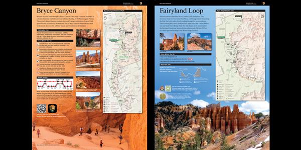
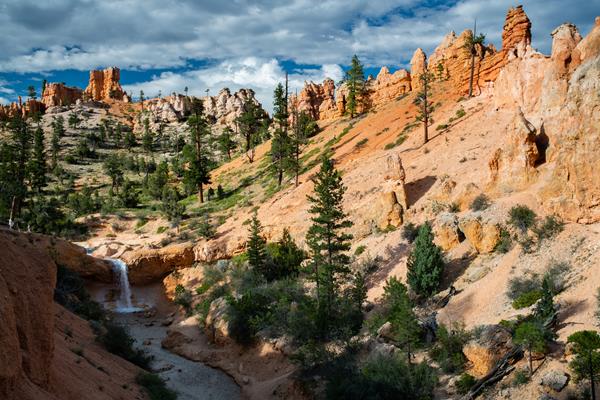
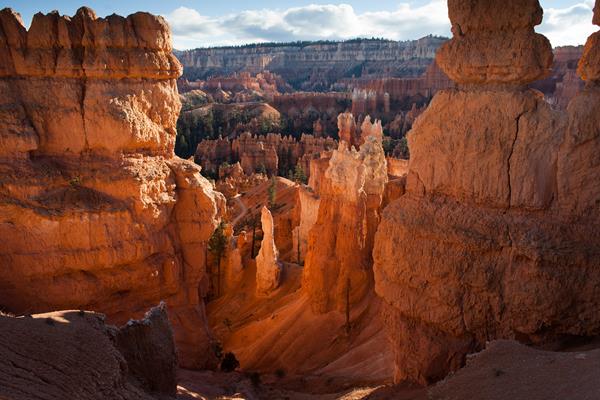
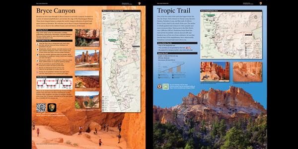
Bryce Canyon
Bryce Canyon, UT
A Lasting Legacy wayside
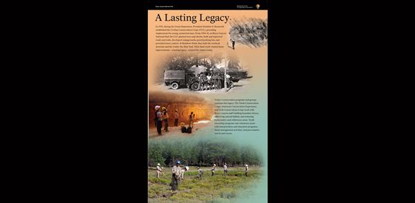
In 1933, during the Great Depression, President Franklin D. Roosevelt established the Civilian Conservation Corps (CCC) providing employment for young, unmarried men. From 1934–41, at Bryce Canyon National Park the CCC planted trees and shrubs, built and improved roads and trails, developed campgrounds, paved parking lots, and provided insect control. At Rainbow Point, they built the overlook structure and the Under-the-Rim Trail.
Agua Canyon Connecting Trail Trailhead at Ponderosa Canyon
Trail Closed due to Rockslide This trail descends 1.6 miles (4.0 km) to its junction with the Under the Rim Trail approximately 1,000 feet (305 m) below.
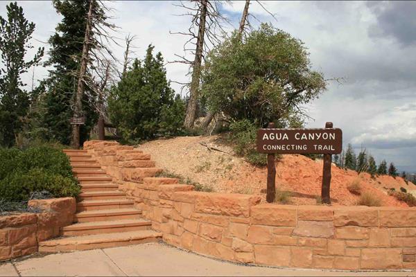
Agua Canyon Trail wayside
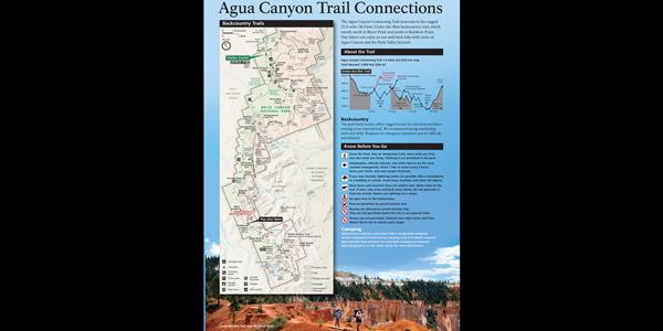
Here, the Agua Canyon Connecting Trail descends to the rugged 22.9-mile (36.9 km) Under-the-Rim backcountry trail, which travels north to Bryce Point and south to Rainbow Point. Day hikers can enjoy an out-and-back hike with views of Agua Canyon and the Paria Valley beyond.
Bristlecone Loop Gazebo
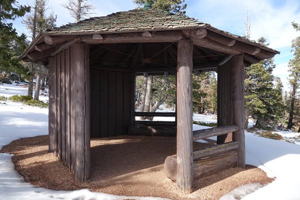
A small octagon shaped log shelter built by the park in the 1980s after the Bristlecone Loop was completed. At this point in the trail you might recognize smaller bristlecone pines nearby. Look for densely bunched needles travelling in a bushy arrangement up the branch. Needles will be in bundles of 5. Two quotations by Henry David Thoreau are framed on the interior wall of the shelter. The first: Silence alone is worth being heard, then "I need solitude. I have come forth to
Bristlecone Loop Trailhead
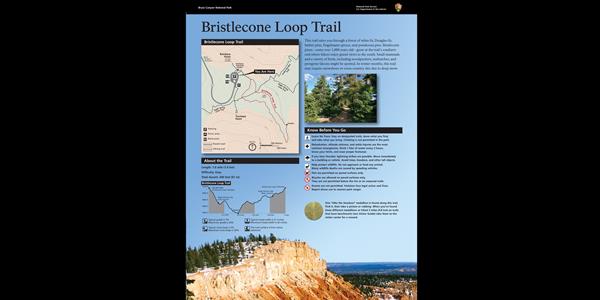
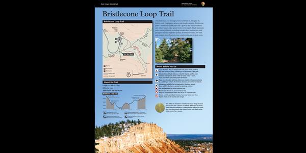
A short path through fir and pine leads to the easy 1.0 mi/1.6 km Bristlecone Loop, as well as the 8.8 mile (14.2 km) backcountry Riggs Spring Loop and 23 mile (37 km) Under-the-Rim Trail. Though the Bristlecone Loop trail only climbs 200 feet (61 m) and is rated as Easy, be sure to carry water, wear ankle-supporting footwear, and postpone your hike if lightning is expected.The Bristlecone Loop reaches elevations over 9,100 feet (2778 m). Here you will pass by bristlecone pin
Bristlecone Loop Trailhead at Rainbow Point
A short path through fir and pine leads to the easy 1.0 mi/1.6 km Bristlecone Loop, as well as the 8.8 mile (14.2 km) backcountry Riggs Spring Loop and 23 mi/37 km Under-the-Rim Trail.
Bristlecone Loop wayside (107)
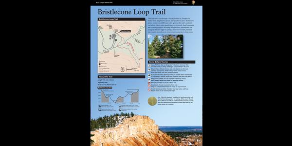
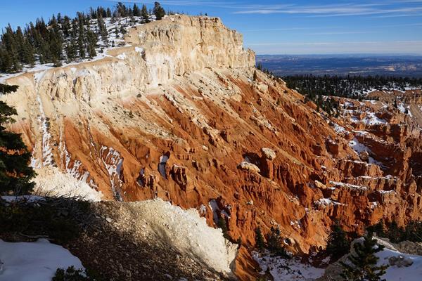
This trail takes you through a forest of white fir, Douglas-fir, limber pine, and ponderosa pine. Bristlecone pines—some over 1,000 years old—grow at the trail's southern end where hikers enjoy grand views to the south. Small mammals and a variety of birds, including woodpeckers, nuthatches, and peregrine falcons might be spotted. In winter months, this trail may be impassable due to deep snow.
Bristlecone Loop wayside (108)
This trail takes you through a forest of white fir, Douglas-fir, limber pine, and ponderosa pine. Bristlecone pines—some over 1,000 years old—grow at the trail's southern end where hikers enjoy grand views to the south. Small mammals and a variety of birds, including woodpeckers, nuthatches, and peregrine falcons might be spotted. In winter months, this trail may be impassable due to deep snow.
Bristlecone Loop wayside (109)
This trail takes you through a forest of white fir, Douglas-fir, limber pine, and ponderosa pine. Bristlecone pines—some over 1,000 years old—grow at the trail's southern end where hikers enjoy grand views to the south. Small mammals and a variety of birds, including woodpeckers, nuthatches, and peregrine falcons might be spotted. In winter months, this trail may be impassable due to deep snow.
Bryce Canyon Shared Use Path
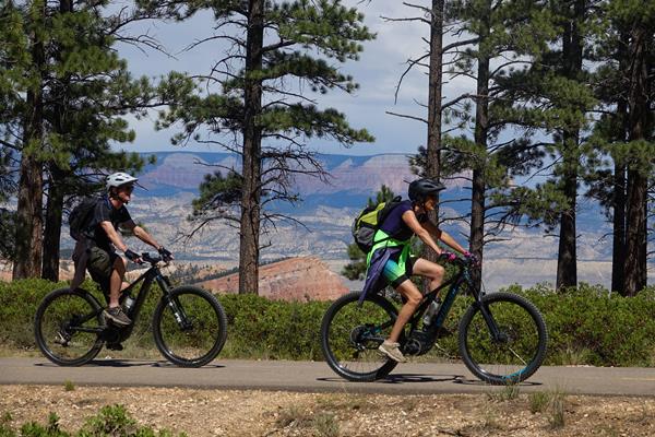
This path provides passage from Bryce Canyon city through Dixie National Forest into Bryce Canyon National Park. Hike, bike, walk or wheel all 5 miles to Inspiration Point, or stop at the shuttle stops and other amenities along the way.
Fairyland Loop Trailhead
The Rim Trail This is the northern end of the 5.5 mile (8.9 km) Rim Trail that begins in the south at Bryce Point. Fairyland Loop The Fairyland Loop is a strenuous 8 mile (12.9 km) loop.
Fairyland Orientation wayside
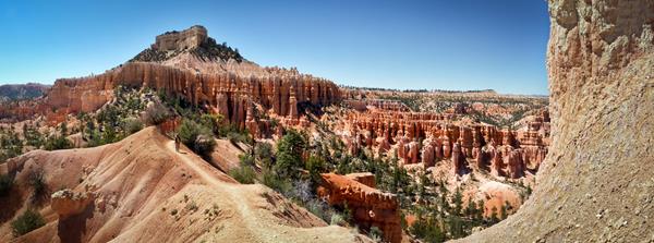
Follow this trail and discover nature’s fairyland of rock castles, cliffs, and spires. It begins with spectacular views from the rim, then continues down into the amphitheater, past fragile, towering hoodoos and cathedral walls. Changes in light create a mesmerizing, colorful palette at every turn. Look for the spur trail to Tower Bridge. Some of the named features along this loop are Boat Mesa, Sinking Ship, and Chinese Wall.
Fighting Fire with Fire wayside
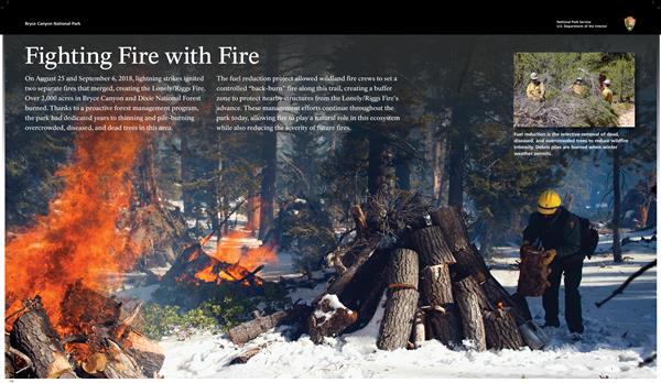
On August 25 and September 6, 2018, lightning strikes ignited two separate fires that merged, creating the Lonely/Riggs Fire. Over 2,000 acres in Bryce Canyon and Dixie National Forest burned. Thanks to a proactive forest management program, the park had dedicated years to thinning and pile-burning overcrowded, diseased, and dead trees in this area. The fuel reduction project allowed wildland fire crews to set a controlled "back-burn" fire along this trail.
Mossy Cave
Mossy Cave trail is one of the lowest elevation hikes in the park as well as one of the only hikes that begins with a climb and ends with a descent (most day hikes in the park begin with a descent and end with a climb). It is also the northernmost hike in the park, located just off of SR 12 as it winds its way through the park boundary.
Mossy Cave Trailhead Wayside
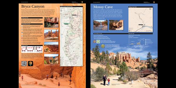
This streamside walk leads to a spring-formed alcove that fills with summer moss and winter ice. At one time, water only flowed through Water Canyon after summer storms and spring snowmelt. After settlers completed an irrigation canal in 1892, water was diverted from the plateau above, steeply eroding these fragile canyon walls and feeding a waterfall that regularly freezes in winter.
Navajo Loop Trailhead
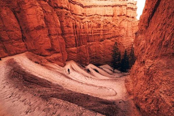
The iconic Navajo Loop Trail begins and ends at Sunset Point, travelling by switchbacks down between narrow walls of colorful limestone with views of towering Douglas-fir trees and the park's most famous hoodoo: Thor's hammer. The loop has two sides, the Two Bridges side and the Wall Street side. The Two Bridges side is open year-round, however the Wall Street side is closed in months when precipitation combines with freezing overnight temperatures.
Navajo Loop Trailhead wayside
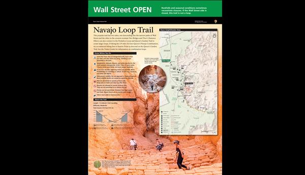
This popular trail has two sides, one descending into the narrow paths of Wall Street and the other to the erosion-resistant Two Bridges and Thor's Hammer. Hikers can also connect to the Peekaboo Loop and Queen's Garden Trail to create larger loops. See the Visitor Guide for information on combination loops.
Orientation Panel waysides
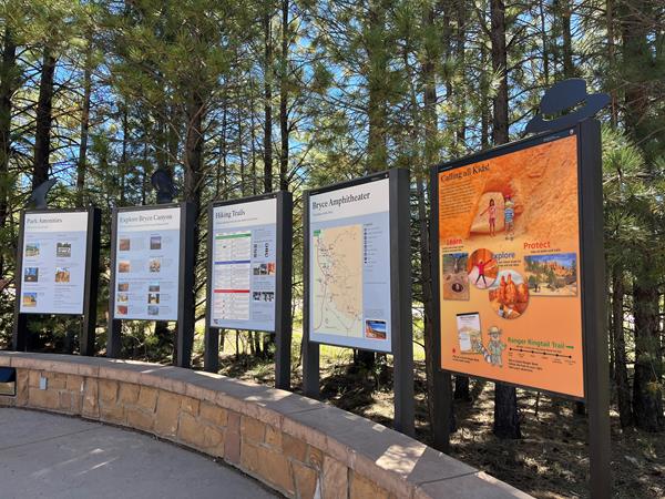
At the entrance to the visitor center are five upright orientation panels along a curved stone wall. The panels provide photographs, maps, text and a chart of information on park amenities, exploring Bryce canyon, the hiking trails, the Bryce Amphitheater, and Junior Ranger activities.
Peekaboo Loop, Hat Shop, and Under-the-Rim Trail Trailhead
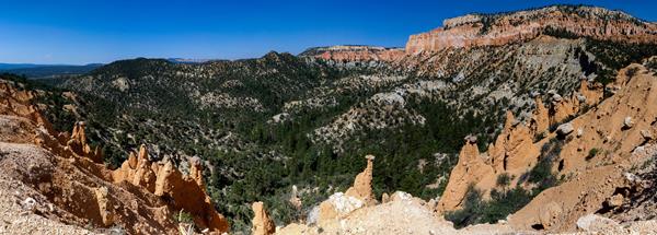
Here the Peekaboo Loop, Hat Shop, and Under the Rim Trails all descend from the Bryce Point area.
Peekaboo and Hat Shop wayside
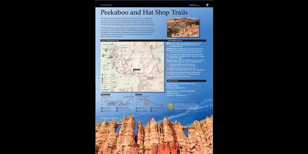
The Peekaboo Loop provides a steep adventure to the floor of Bryce Amphitheater. Both sides of this strenuous loop provide many climbs and descents through a forest of hoodoos. Return up to Bryce Point or connect to Queen's Garden, Navajo Loop, or Tropic trails at the northern junction. Clockwise travel is requested due to horse use. The Hat Shop Trail descends 1,000 feet (305 m) along the first 2 miles (3.2 km) of the much longer 23-mile (37 km) Under-the-Rim Trail.
Ponderosa Canyon
Ponderosa Canyon is so named because of the huge Ponderosa Pines on the canyon floor. Some of these trees measure more than 5 ft. in diameter and exceed heights of 150 ft.
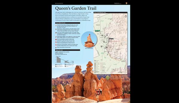
Queens Garden Trailhead
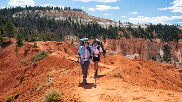
One of the park's most popular trails, the Queen's Garden trail descends and bends 0.9 miles (1.4 km) along a ridgeline down to a unique hoodoo said to resemble Queen Victoria. Of the six trails that descend into the Bryce Amphitheater, the Queen's Garden Trail is considered the least strenuous; though due to the park's high elevation and steep grades in some areas, it is still categorized as a moderately strenuous hike.
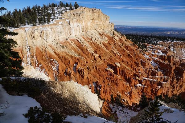
Rainbow Point Orientation wayside
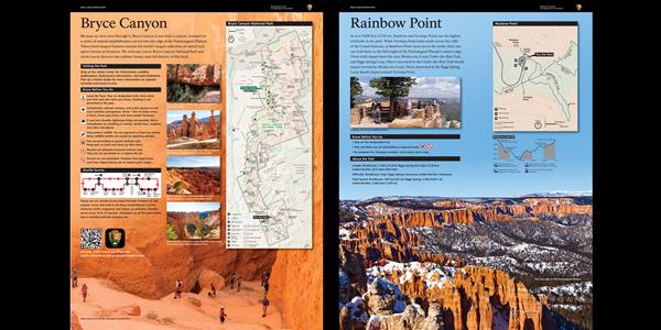
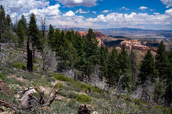
At over 9,000 feet (2,743 m), Rainbow and Yovimpa points are the highest overlooks in the park. While Yovimpa Point looks south across the cliffs of the Grand Staircase, at Rainbow Point views are to the north. Here one can look back on the full length of the Paunsaugunt Plateau's eastern edge. Three trails depart from this area: Bristlecone Loop, Under-the-Rim Trail, and Riggs Spring Loop.
Riggs Spring Loop Trailhead at Yovimpa
Experience the solitude of Bryce's forested backcountry on the Riggs Spring Loop. Descending from the rim, this 8.8 mile (14.2 km) trail meanders through forests and raised promontories, offering stunning views of pink-hued cliffs in the distance.
Rim Trail Bryce Point Trailhead

This is the southern end of the 5.5 mile (8.9 km) Rim Trail that begins in the south at Bryce Point and ends in the north at Fairyland Point.
Rim Trail Bryce Point wayside
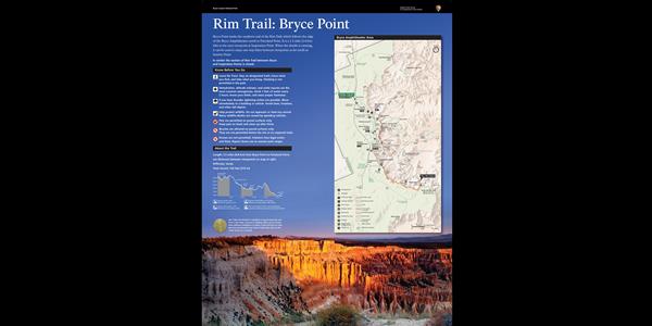
Bryce Point marks the southern end of the Rim Trail, which follows the edge of the Bryce Amphitheater north to Fairyland Point. It is a 1.5 mile (2.4 km) hike to the next viewpoint at Inspiration Point. When the shuttle is running, it can be used to enjoy one-way hikes between viewpoints as far north as Sunrise Point. In winter the section of Rim Trail between Bryce and Inspiration Points is closed.
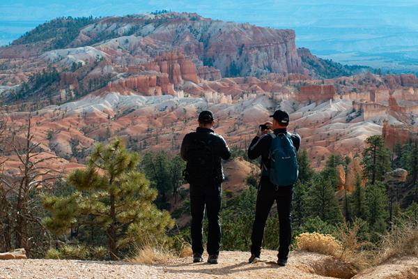
Rim Trail Inspiration Point Trailhead
The 5.5 mile (8.9 km) Rim Trail begins in the south at Bryce Point and ends in the north at Fairyland Point. The trail connects all viewpoints in the Bryce Amphitheater area and can be accessed at each of them. From here, turn left to travel north to Sunset Point. Turn right to travel south to Bryce Point. Note that the section between here and Bryce Point is closed in winter.
Rim Trail Sunrise Point Trailhead

The 5.5 mile (8.9 km) Rim Trail begins in the south at Bryce Point and ends in the north at Fairyland Point. The trail connects all viewpoints in the Bryce Amphitheater area and can be accessed at each of them. From here, turn left to travel north to Fairyland Point. Turn right to travel south to Sunset Point.
Rim Trail Sunset Point Trailhead

The 5.5 mile (8.9 km) Rim Trail begins in the south at Bryce Point and ends in the north at Fairyland Point. The trail connects all viewpoints in the Bryce Amphitheater area and can be accessed at each of them.
Rim-Trail Inspiration Point wayside
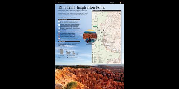
Hikers can enjoy an easy 0.7-mile (1.2 km) walk north to Sunset Point above the Silent City, or a moderate 1.5-mi (2.4 km) hike south along steep cliffs to Bryce Point. When the shuttle is running, it can be used to enjoy one-way hikes between viewpoints as far north as Sunrise Point.
Shuttle Stop 7: Sunset Campground Southbound
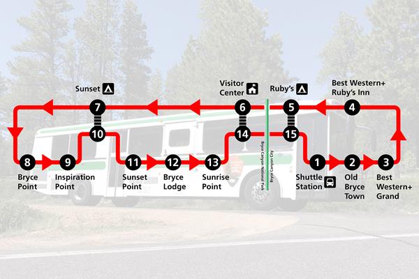
Shuttle Stop located on the southbound side of the main road near Sunset Campground.
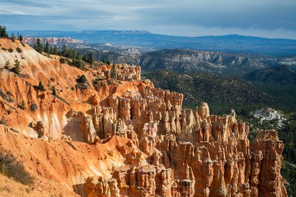
Sunset Point
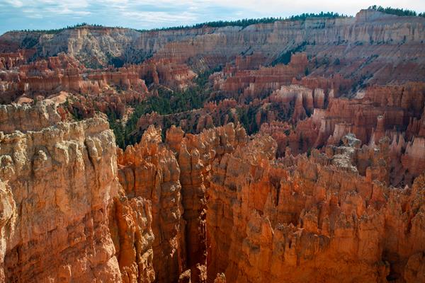
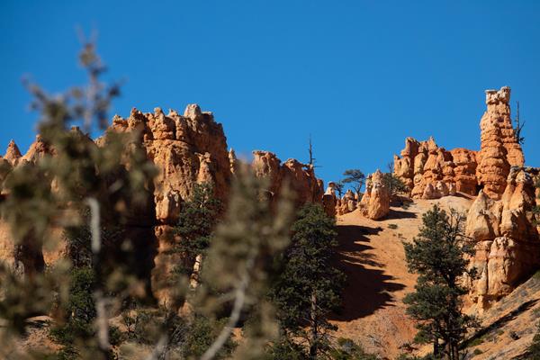
Sunset Point offers vistas of some of the most famous and breathtaking of Bryce Canyon's hoodoos. Nowhere are the colors of Bryce Canyon's rock better displayed than from Sunset Point.
Swamp Canyon
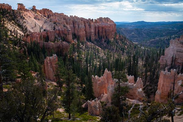
Swamp Canyon completes the transition from the hoodoo-filled Bryce Amphitheater to the steep cliffs and buttes that characterize the scenic drive and southern end of the park.
Swamp Canyon Connections wayside
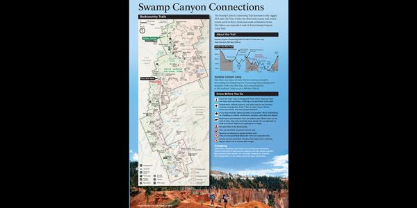
Here, the Swamp Canyon Connecting Trail descends to the rugged 22.9-mile (36.9 km) Under-the-Rim backcountry trail, which travels north to Bryce Point and south to Rainbow Point. Day hikers can enjoy the 4-mile (6.4 km) Swamp Canyon Loop Trail.
Swamp Canyon Loop Trailhead
The moderately strenuous 4.0 mi/6.4 km Sheep Creek/Swamp Canyon Loop begins here. The trail descends 647 ft/198 m to the canyon floor on a 3 - 4 hour hike. The loop is created by combining the Sheep Creek Connector Trail with 1.1 mi/1.8 km of the Under-the-Rim Trail and the Swamp Canyon Connector Trail.
Tower Bridge Hike the Hoodoos wayside

Hike the Hoodoos Hiking is great exercise and Bryce Canyon's "I Hiked the Hoodoos!" program is not just hiking, it's also a scavenger hunt with a special reward!
Tower Bridge and Fairyland Loop Trailheads
Similar in difficulty to the Queen's / Navajo Combination loop, but far less travelled, the Tower Bridge trail provides excellent views of Boat Mesa, Sinking Ship, and other distant features within and outside the Bryce Amphitheater area of the park.
Tropic Trail Trailhead
One of the least-travelled front-country trails in the park, the Tropic Trail provides a unique point of entry into the Bryce Amphitheater area of the park. While all other hikes in this area begin on the rim and descend into the amphitheater, the Tropic Trail begins in lower elevation forest and steadily climbs to its intersection with the Peekaboo Loop, Navajo Loop, and Queen's Garden Trails.
Tropic Trail wayside
One of the few trails in the park that begins below the rim, the Tropic Trail connects to Navajo Loop, Queen’s Garden, Peekaboo Loop, and Rim trails. It follows Bryce Creek, which is dry much of the year. The incline is initially gradual and connects to other popular and more strenuous hikes. Total ascent to the Rim Trail is over 1,000 feet.
Under-the-Rim and Riggs' Spring Trailhead
The Under-the-Rim Trail is approximately 22.9 miles (36.9 km) from Bryce Point to Rainbow Point. Connecting trails offer access from the park's Scenic Drive and intersect the Under-the-Rim Trail at Swamp Canyon, and Whiteman Bench. Agua Canyon Connector Trail **is closed** until further notice due to storm damage.
Whiteman Connecting Trail Trailhead
Experience the solitude of Bryce's forested backcountry on the Under the Rim Trail. Descending from the rim, this 22.9 mile (37 km) trail meanders through forests and meadows, offering stunning views of pink-hued cliffs in the distance.
Whiteman Trail Connections wayside
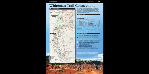
Here, the Whiteman Connecting Trail descends to the rugged 22.9-mile (36.9 km) Under-the-Rim backcountry trail, which travels north to Bryce Point and south to Rainbow Point. Day hikers can enjoy an out-and-back hike with views of the Paria Valley and Swamp Canyon.
Yovimpa Point Connections wayside

From here hikers descend on the 8.6-mile (13.8 km) Riggs Spring Loop Trail. Those looking to hike the rugged 22.9-mile (36.9 km) Under-the-Rim Trail, which travels north to Bryce Point, should begin near Rainbow Point. Day hikers might enjoy the nearby Bristlecone Loop or views of distant mesas and steep plateau cliffs along the strenuous Riggs Spring Loop.